
Grayson Gravel 150 Bike Ride, Mt. Roger’s, and Wild Ponies
- Feb 18
- 9 min read
Updated: Feb 19
When we moved to Blacksburg, VA, one of the first things that we did was search for bikepacking loops in the area. After all, what better way to learn a new place than to slowly pedal through all its nooks and crannies at a more intimate pace than in a sheltered metal box (read: car).
The Grayson Gravel Circuit was one of the first digital hits on our radar, and it particularly peaked our interest because it was A) in the region of Mt. Rogers (the tallest point in the state), and, most importantly, B) it had wild ponies! We wouldn't realize it until later (far into the ride when the ponies suspiciously weren't showing up), but the ponies are really only accessible by foot traffic when you start hiking up the Wilburn Ridge and sections along the Appalachian Trail towards Mt. Rogers (gosh darn, one of these days I will do my research). Our bike tour wasn't going to even touch these areas, but I still held out hope for every hillside and yonder to provide an equestrian surprise.
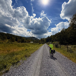
The metrics: the total route boasted 143 miles, 14,699 ft of gain, and a 50:50 paved/gravel route, so we knew it would be challenging. Did I mention we were out of shape?
Day 1
44.5 miles and 4,820 ft elevation gain Strava Map
Early September 2025, we arrived at the parking lot in the morning, about a 3 hour drive south from Blacksburg. The lot was completely spacious yet empty–– a local later telling us that it was usually packed before Hurricane Helene blew out the Virginia Creeper Trail. Many months later, the trail still wasn't repaired, so traffic dropped substantially.
The sunny weekend ahead, we strapped our bags to our bikes (reminiscent of gearing up for battle) and began the morning by weaving on some sleepy, paved roads. So sleepy, in fact, that I craved sugar and caffeine within the first 3 miles––I was falling asleep at the handlebars. A hard right turn into the first gas station, I hoped the packaged goodies would work their magic....quickly. A wall of road lay very shortly ahead.
And the first 12 miles were the longest I've ever experienced [no thanks to the faulty sugar snacks I bought]. Was it being out of shape? Was it my overly thick mountain bike tires that stuck to smooth pavement like peanut butter? Or perhaps it was the insanely steep winding roads that never ended, with goading false summits? Maybe I'm getting old at my ripe age of 30?? No definitely not that. Going 3 mph leaves a lot of time to wonder why your bike/body aren't doing what they should be doing in the way you want.
When biking became so slow that walking would be faster, it was also hard to not appreciate the beauty of the surrounding landscape, literally looking at any and everything as a distraction. I was used to the rolling hills of Upstate New York, roughly carved away by glaciers that left scars in the terrain. These hills were different––the rollers were steeper and more densely forested. Service was non-existent. The hillsides were packed full of.... Christmas trees? Seriously, we were shocked by the quantity of Christmas tree farms loading the horizon. The early Autumn colors were adding to the loveliness: waving fields of greens and yellows, sprinkled with dots of livestock.
A little appreciation for the road conditions: Despite my gravel bike being out of commission and me being forced onto the mtb, the gravel roads were chef's kiss. The very long uphills were matched with just as long downhills on perfect champagne gravel, void of cars and people. The periodic farmhouse would paint the horizon in a Christina's World kind of way. The warm breeze and full sunny skies with chunky clouds lazily drifting by were dreamy. Perfect for a picnic in the fields, reading a book, and watching the sun cross the sky.
Did I mention I was out of shape? By the end of the day, the hard elevation gradient left its mark on my [30 yo] knee with a twinge sending me a warning. Good news though, Uri's 6-month sprained ankle was finally well-behaved and giving him hope that recovery was imminent.
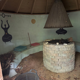
Perhaps one of the best parts of the day (and tour) was our funky oasis for the night at Oracle Campground. We ended the day at this retreat where it was just the two of us there. A peaceful shallow creek ran through the campground with little whimsical baubles hanging in the trees. A fairy pool and sauna hut added to the magic, though was also a bit spooky given how empty the place was. The fairy eyes seemed to follow you...
Perhaps the most luxurious amenities I've ever had on tour were the hot shower and outdoor kitchen.
It's very rewarding doing hard things, but I'm coming to enjoy having small comforts like this on tour. Call me crazy.


Day 2
52.5 miles and 4,826 ft of gain: Strava map 1 and map 2
We packed up camp efficiently and boogied to the nearest gas station in Independence. A trio of old men sat in the corner in a row, their backs to the wall, observing all the comings and goings of the store. I had no doubt that these men gathered here daily for the reality gas station TV, that was now featuring me in my bike attire, pouring a tall stiff cup of drip coffee. We chatted briefly, engaging in the usual where-ya-comin-where-ya-goin banter. More importantly, I stuffed down a PUMPKIN whoopie pie. What can I say? I'm a sucker for autumn themed treats and Pennsylvania delights.
Finally, I mentally and physically kicked into gear. Was I faster? No. But, I was locked in with newfound energy that completely changed my attitude towards the day. My knee was also done having a fit and was ready to go for Part 2.
Around lunchtime, we made a stop in Fries! I later gathered it was pronounced like "Frees", but that didn't stop me from ordering diner curly fries; When in Rome. We paused to dine at a picnic table in the park and took the sunny opportunity to dry out our tent which had soaked from the morning dew.
Up, Down, Up, Down. Our day was a slow and steady roller coaster. At some point, we curved our counterclock loop and began to round out back west. For entertainment, we started listening to an audiobook together, something to help take our minds off the effort. We probably could have picked an Appalachian writer to immerse ourselves in the culture and tales of the south, but the reality is that we just listened to fantasy smut.
Hills? What hills?
As usual with the south, we biked past so many churches. For how rural and empty the countryside was, it was a shock to see so many churches in such a small radius. Do they get enough attendees? Is there drama about which church you go to? The perk to this, though, is that we can often sleep behind one for a quick night without garnering trouble or suspicion. I mean, come all who are weary and I'll give you rest, right?
One particular church had an outdoor pavilion and community center that seemed the most ideal for two tired bike travelers. We tucked in the pavilion, out of sight from nearby neighbors, yet our plan was foiled. A dog relentlessly barked at us for about an hour or so, the owner peeking around to see what the fuss was about. It was highly unnerving and grating to listen to, so we packed up again and headed out, now off-script.
New plan: start to bike uphill into our Day 3 route to look for a new sleeping spot. Heavy emphasis on the Uphill. The evening was beginning to close in, and as we cranked up the mountain, we were disheartened by the steep grade to our left and the pitching cliffs to our right. Every now and then a semi-flat surface appeared that promptly had a Posted: No Trespassing sign.
It was getting dark now, and we spotted a short side road that briefly went uphill to a gated road. There was evidence of an old campfire and beer cans, and the gate was yellow, much like a forest service road gate. Beyond the gate was an unmaintained brushy path with fallen trees–– surely no one would be passing through here anytime soon. We have been kicked out of places many times before, and it's always stressful to have to abandon a camp spot when your only mode of transport is a bike...and it's night. After a short deliberation session, we committed to this abandoned, junky, party vestige.
We pitched our tent in this little nook of a spot and ate some packaged food (tuna packets, ramen, the usual). Around 9:30 PM, after we began to fall asleep and I settled into the idea that it would actually be OK here, a truck pulled into the road and beamed headlights into our tent. My anxiety spiked, and I painfully waited for the truck door to open and close, the sound of boots walking towards our tent where a forest ranger would say "Knock knock" and tell us to pack it up. But it never came.
The truck backed up and pulled out. To get reinforcements? Or were they just looking for a spot to party or hookup?
"You know," I said cautiously to Uri, "this is the kind of place where you get shot for trespassing."
At the immediate conclusion of my sentence, we heard a round of gun shots sound through the forest. At 9:30 PM.
We had a tough time falling asleep after that, but fortunately the morning came with no other surprises.


Day 3
44 miles; 4741 ft of gain; Strava map
After a brief acknowledgement that we made it through the night without trouble, and that we hoped this never happened again, we were impatient to move on from our makeshift camp spot. After scrounging some granola bars and assessing our dwindling food and water supply, we continued with our final day of the tour. Fortunately, we were already 5 miles into the day, taking the edge off a 50-miler.
Yet, today was still a painful one. Not for the hard hills, though. No, today's beast was my very own bike saddle, the traitor. All of my consciousness was focused on the sores, and I experimented with different ways of sitting or standing up on the bike. The whole day was full of groans and calculated deep breathing to work through the suffering. I had never yearned for the cushy car seats as much as I had now, and I began to question why I did this with my spare time.
We also had absolutely 0 services all day, including cell service to look up the location of food/water services. The remoteness was only part of it; it was also Labor Day, so the would-be-open stores were all closed. We began to scout every church we saw for an outdoor spigot, which usually was fruitful but today was Sahara Desert dry.
A man and woman doing yard work were our saving grace. We reigned in our desperation to politely ask if they could fill our bottles. "Yeah we ran out, haha." They didn't hesitate.
And then we powered through the rest of the way home! The empty gravel roads and rainbow roadside flowers were pure autumn loveliness. We consumed all the rest of our food, timing it near-perfect to end back at the car hungry but not impossibly so. A quick visit back at our first gas station, we inhaled sub-par pizzas, capping off the tough physical journey with an unrewarding gastro one.
And OOF what a trip! It would take some time for this one to feel rewarding, but I'm really glad to have experienced this beautiful and underrated part of the country.
Ponies incoming...


A two-day backpacking loop to see the ponies! For real!
We finally made it a plan to see the wild ponies no matter what, and it seemed like the Wilburn Ridge was the sure way to do that. So, over the course of 2 days and ~22 miles, we dusted off the ol' backpacks and hiked through dense groves of rhododendrons, feeling like we were in a wild jurassic-age forest.
It was a sunny November weekend, though temperatures were dropping. Ice formed on the tops of the trees, increasing in quantity as we ascended towards Virginia's tallest peak. The meteorology was conflicting though: despite the sunshine, ice feathers rained in clumps, creating the unique pairing of winter and autumn toggling back and forth around each corner.
The hiking was high quality, with periodic vistas over grassy fields and through forest openings. At a fork, we ditched our packs to detour quickly to the top of Mt. Rogers and back. It didn't have a view, but the forest was steaming: the frosty ground was evaporating before our eyes in the beams of sunlight like a foggy sauna. We were properly wet from the "rain", but it was warm enough to just billy goat frolic back down the trail and not worry about temperature safety.
We scrambled over rocks, hiked through Fat Man Squeeze, celebrated a new proposal, and, finally, 11 miles in, saw the ponies!
It was a small number as the herd was dispersed, but here they were, munching away unperturbed. We snacked alongside them, enjoying the beauty of seeing these wild creatures against the back drop of the blue ridge mountains.
Two miles to go, we snagged a lean-to just down the Wilburn Ridge, and we were the only guests for the night. Embracing the pleasures of hot food (Not sorry Talenti cold soak), we ate a million calories of gooey mac and cheese and squirmed into our sleeping bags until morning. There's something fundamentally satisfying about going to bed with the sunset, no screens or electricity prying us awake.
Next day, we had bigger plans to hike a larger loop, but not carrying pack weight for a while and walking on uneven terrain had my hips and knees sending me a glaring warning. With no guilt whatsoever, we beelined down the Wilson Creek trail cutoff, and streamlined back to the beginning, briefly intersecting the same road where we biked previously. How cool it is to intersect a place where historic you had been.


Feel free to leave a comment below, and let me know what you think! You don't need to create an account or sign in, just give yourself an alias and leave your mark! I'd love to hear from you.