
A weekend biking the Rothrock Rambler in Pennsylvania
- Jul 11, 2025
- 9 min read

I grew up in Pennsylvania, though my appreciation for the densely and deciduously-forested state would only come after I moved away. As an adult, I had never explored it intentionally for recreation, only seeking out the pockets where family lived. Sure, my parents would take us camping as children, but it's not the same as building your own adventure and navigating the challenges yourself.
Living in Upstate New York for 7 years, my interest in gravel bike riding has grown rapidly, and my sights have turned back on the rural areas of my home state. Groups like Pennsylvania Dirt Bags and Bikepacking.com have introduced me to epic routes and adventures (grand and small), and as I pan around photos and maps, I feel nostalgic towards the familiar landscapes: the rolling hills, old farm houses and barns, the Amish horse and buggies.
In my Notes app, I pinned a number of summer wishlist rides, the Rothrock Rambler being on top of the list. Just a few miles south of State College, this overnighter route boasts 112 miles and 9,998 ft of elevation gain––not too shabby for a 2-day excursion. In the 1800s, the forests in this area were clear-cut for the blast furnaces, but the state of PA eventually bought these forests. Following that, the Civil Conservation Corps then built well-maintained gravel roads through them, and, as a result, there are countless campsites, hiking trails, and bike riding routes, offering a weekend of endless recreation opportunities.
Typically, I would enjoy a ride like this with my husband, but since he was out with a sprained ankle from marathon training, I would be physically riding alone. However, this also meant I would have the rare luxury of him meeting me at the campsite and along the route for support, towing bougie camping supplies, coolers, stoves, and extra food and water.
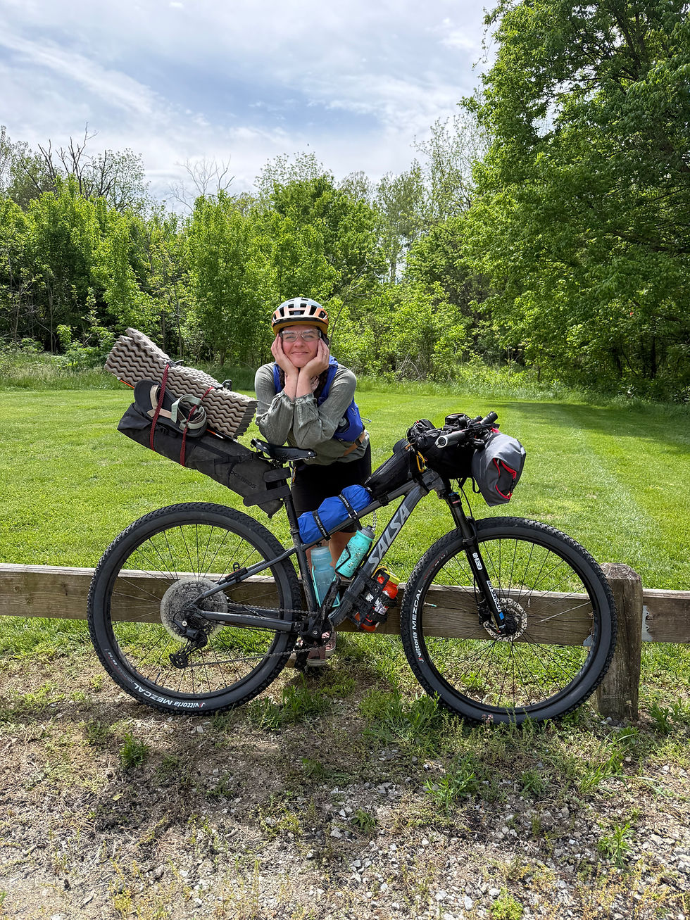
Often, I find myself underbiking––using a bicycle that's not entirely up to the terrain challenge. For this trip, I was mostly confident that what I had would be functional. My beloved bike, Salsa Verde (otherwise nicknamed Sweet Pea) is a Salsa Journeyer Sora with tubeless tires that desperately need replaced with something with a semblance of tread. I'm also using some small fork panniers (for extra snacks and bike repair tools) and my wonderful Brooks saddle. For extra water, I've started carrying a hydration vest, especially because services are minimal along this route.
Day 1: State College to Reeds Gap State Park
57 miles, 5,194 ft gain: Strava map
Uri and I stuffed the car for our weekend excursion, bogged down with more camping luxuries than we are used to (a Coleman, whaaat?), and drove the 3 hours south to State College. The start of the route was on a quiet, forked gravel road with ample parking that allowed for overnight cars, though Uri would be driving to meet me at the campsite––specifically, camp #6 identified on the Bikepacking map.
With the route loaded and ready on my Garmin, I kicked off and commenced the day with a zoomy and paved downhill, lasting about 4 miles. Had I been in the mood for an immediate break, I would have stopped at the Naked Egg cafe right at the beginning of the route. Instead, I warmed up quickly on the hot and open 10 miles of pavement when the gravel roads finally emerged. Fortunately, gravel was usually synonymous with canopy coverage as the forest protected me from the beating sunlight. The highest elevation of the trip was also the very first hill of the day, upon instant entry to the Rothrock State Forest, lasting until mile 14.
In unique fashion for the east coast, I plowed through some switchbacks, weaving and stitching my way up the "mountain" (hill?), grinding to the Boalsburg Fire Tower. The terrain turned from small compact gravel to larger rocky boulders, a little rougher/bumpier than preferred on the out-and-back from the tower, though it was a short enough distance to power through. The fire tower emerged bright red through the trees, though closed off for climbing due to vandalism. Unfortunately, as I was dripping with hot sweat, my phone in my fanny pack had been bouncing, attempting to unlock over and over. Consequently, I was locked out for an hour and couldn't take photos here.
After a steep descent back down from the tower, a second smoother climb ensued, and on the way, I had a fortunate stop at a fresh spring on the roadside where another cyclist had just finished refreshing and refilling his bottles. The water was icy and delicious as the humidity socked in and made the air heavy. Though I had Uri for backup water supply if needed, stopping here was necessary as there weren't many other resupply spots along the route.
The climb crested, and at the summit on N Meadows Rd, an overlook rewarded my hard and sticky efforts. It was muggy, but the rolling, forested hills curved prominently on the horizon, and the roadside was smattered with wildflowers and pollinating insects. I took a pause here, snacking and catching my breath before flashing down the perfect and long doubletrack gravel that ended at Colyer Lake.
Colyer Lake was roughly halfway to the campsite. It was quite a large water body, and many folks were picnicking, kayaking, and fishing. Though the icon on the map indicated swimming opportunities, it did not appear that swimming was open everywhere along the lake (and not where we were at on the route). To my delight though, Uri had set up a small aid station, with our folding chairs facing the lake and snacks ready for a lunch stop. Such a treat!
I was still feeling fresh and strong at this point, but the heat was mounting. After departing, I had 2 additional large climbs between miles 36 and 42; however, a massive thunderstorm was rolling in. Uri called me hurriedly, advising that I seek shelter as branches were falling into the road. I glanced to the still-blue sky and noticed the darkness creeping behind me ominously. There was nowhere to take cover near me, so I picked up the pace to attempt getting to a town, though the two hills thwarted my speed. Rain drops began light and then turned to shower, surprisingly delightfully soaking and cooling me off. As the thunder rumbled, I glanced often for lightning, making a mental plan to chuck my metal bike one direction and dive for the trees in the other direction if any electricity buzzed. Meanwhile, I enjoyed the solo time in the heavy deluge, slowly chugging up rural gravel roads where the presences of houses and people remained minimal or nonexistent. My stop at the Big Valley Vista overlook was expedited as I did not want to be the only metal-wielding thing in an open landscape.
The next part of the day was my favorite. After a damp downhill that always reminded me to get front and back fenders, I cruised through the flat, rural farm fields. Amish buggies took to the streets following the storm, and I waved to the folks riding, some friendly others stern. The sunlight emerging from the storm clouds reflected off the water reflections on the roads, and the barn silos contrasted bright red against the misty, rolling green backdrop.
I had a brief pause in Milroy where an ice cream stop was on route, though I was secretly craving whoopie pies. Whoopie pies are an Amish and New England treat, resembling a chocolate sandwich cookie (with more of a cake-consistency) and a marshmallow/frosting filling. A number of states in New England claim to be the birthplace of the whoopie pie, though I support the conclusion that the PA Dutch Amish were the originators (Sorry, Maine). To my dismay, whoopie pies weren't being sold here, though I made it my mission to find one before going home!
With just 700 ft of gain and 3 miles keeping me from the campsite, I pushed through, very ready to finish for the day. The road was unaptly named Flat Rd, being everything but. My slow uphill pace encouraged a swarm of bugs to form a cloud around my face, easily keeping speed with me for miles. Fortunately, they weren't biting, but it was a major annoyance as they would get in my eyes, and I would suck them up my nose. When I finally arrived to Campsite #6, I looked like Pig Pen from the Peanuts, the moving cloud billowing around me, soiling Uri's pristine and insect-less site.
And the place was great! It was a big grassy field surrounded by woods with a fire pit and picnic table. We pitched our tent, set up our Coleman, and began cooking a feast.
The only minor problem was that someone else had booked this site, unknown to us. It was totally our fault too––we just followed the route to this campsite as shown on bikepacking.com. However, there are many campsites all through the state forests, and they all need to be reserved in advance. Classicly, I just didn't read any of the instructions before hopping in the car and starting the route (oops). So, the kind guy in his jeep waited for us to pack up our things and do the walk of shame out of the site as we brainstormed where to go at 7:30 PM.
Fortunately, we had the car, and I wasn't totally screwed being on my bike. We booked an after-hours campsite at Reeds Gap State Park where there were 3 extra walk-in sites available. Though we didn't take advantage of it at the time, there was a deep creek that ran though the camp that would have been perfect for a swim, and the campground had showers that added to the luxury of our weekend. Crisis adverted!
We went to bed early, but not before appreciating the soft glow and flashing of the PA lightning bug, our state insect, illuminating the surrounding forests.


Day 2; Reeds Gap to State College
53 miles, 4,137 ft gain: Strava map
We had a semi-slow morning at camp, though I was groggy and baggy-eyed from the sticky, humid sleep. The downside of summer camping can be the synthetic materials of camping gear, and I remained pasted to my sleeping pad and bag for hours until I caught some sleep right before sunrise. In the future, if I am car camping, I would carry a more breathable blanket/sheet with me.
After some coffee, eggs, and bread, we drove the 15 mins back to where I left off yesterday, around Campsite #6. Unlike the previous day, I wouldn't have a rain shower to cool me down. Instead, my weather icon for today was a full, unobstructed sun. The morning dew was already burning off through the trees, creating a haze through the sunbeams.
The morning immediately began with a moderate uphill, followed by a breezy downhill to Alan Seeger National area. This area was named after the American poet who died in WWI, though he never visited the region. Biking through offered a new, almost whimsical landscape of massive rhododendrons and old growth pines and hemlocks. It was quiet, charming, and a delightfully flat meander.
Cruising along with a fun descent, I arrived at Whipple Dam State Park where Uri and I took a snack break. Cell reception was very bad all through this area, though we managed to coordinate the meet up through pockets of service. Though it was getting warm and there was an actual area for swimming, the water was icy and few folks chose to brave the temperatures. I wasn't prepared to get wet yet either, so I parted from Uri while he stayed a while longer.
Shortly after leaving Whipple Dam, signs advertising Bridge Out periodically were planted along route. As usual, I proceeded in the hopes that I could tactfully slip on by without any issues. The shallow ravine was hardly problematic as I carried my bike across the rocky stream and up the other bank.
I had three steep climbs remaining for today, and all three required me to slow down substantially enough where a cloud of bugs would, again, swarm my face. For hours, I coughed on the fruit fly-looking insects, breathing them up my nose and picking them out of my eyes. It was hard to concentrate on much else, which could have been a welcome distraction from the long uphills.
On Colerain Rd, near the peak of the final large hill, I had a stunning overlook of the valley, flowers blooming.
The remaining 12 miles to the end had constant casual rolling hills that kept the quads engaged, though were nothing too strenuous. Brady and Forest Rd (nearing the finish line) converted to chunkier, loose, gravel rocks which were the toughest on my tires and joints, so I let out some air to not jostle around as much. One day I will upgrade my tires to be wider and with tread!
Finally, I made it to the end, back to the gravel fork in the road. Uri was there and surprised me with a Sheetz whoopie pie that I had been craving (!!!) Sheetz is a classic PA gas station with a mild cult following, lending to the contentious argument of which gas station is better, Sheetz or Wawa (Sheetz, obviously!). The overly sweet, cakey delicacy was just what I needed...and spicy curly fries after we returned to Sheetz for round 2.
With a quick jug-o-water shower in the parking lot, I washed off the sweat, sunscreen, and grime, and we began the trek back home. Another successful weekend warrior excursion!
Overall, the gravel on this route was perfect! There were barely any pot holes, and the roads were perfectly maintained. The hills were strenuous at times, but much of the difficulty came from the heat, bugs, and thunderstorm. There also were very few services and towns to break up the monotony, and I barely saw other cyclists. Much of the ride was done alone, except for when Uri would meet me along the way.
I look forward to checking out more routes in PA!


Comments